Savannah’s mix of historic streets, tourist traffic, and high-speed corridors creates collision hotspots where crashes happen daily. You’re navigating narrow downtown lanes one moment and dodging aggressive drivers on Abercorn Street the next. Understanding where car accidents occur in Savannah helps you recognize dangerous areas and strengthens injury claims when crashes result from predictable hazards.
Certain intersections, roadways, and neighborhoods see far more collisions than others due to poor design, confusing traffic patterns, and driver behaviors that turn routine trips into dangerous situations. Knowing these high-risk locations matters because crash history at specific sites helps support negligence claims when drivers fail to exercise appropriate caution in known danger zones.
Key Takeaways for Savannah Car Accident Locations
- Abercorn Street, particularly near Montgomery Cross Road and Oglethorpe Mall, is a dangerous corridor with frequent rear-end collisions, left-turn crashes, and aggressive driving.
- Downtown Savannah’s historic squares and one-way streets confuse drivers who are unfamiliar with the area, leading to wrong-way crashes, pedestrian accidents, and collisions at confusing intersections.
- I-16 ramps entering downtown and Truman Parkway merge points see high-speed crashes when drivers misjudge gaps in traffic or fail to yield properly during lane changes.
- Georgia law under O.C.G.A. § 40-6-20 requires drivers to obey traffic-control devices such as lights and signals and drivers must also exercise reasonable care based on road and traffic conditions, especially at intersections with known hazards.
- Crash location history strengthens legal claims by supporting arguments that drivers should expect greater risks and use extra caution at documented danger zones.
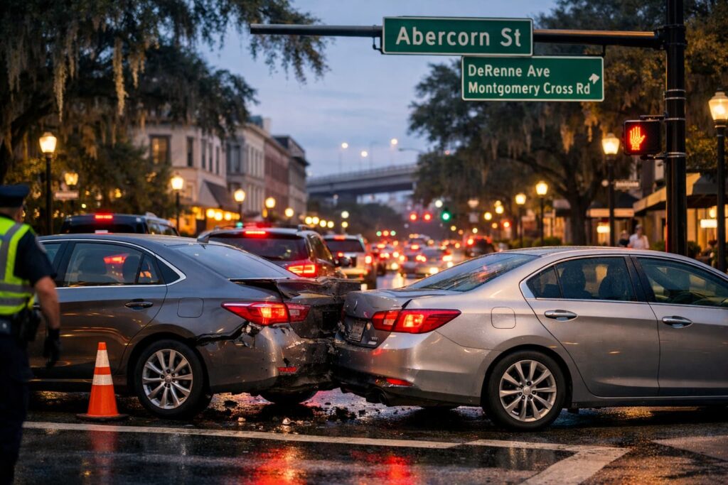
Abercorn Street: A Dangerous Savannah Corridor
Abercorn Street runs through Savannah like a main artery that’s perpetually clogged. This major north-south route carries massive traffic volumes while featuring confusing intersections, aggressive drivers, and constant congestion that creates rear-end collisions daily.
Driving Abercorn means dealing with cars weaving between lanes, drivers racing to beat red lights, and sudden stops that create chain-reaction crashes. The corridor’s crash frequency makes it a notorious accident location.
Abercorn and Montgomery Cross Road
This intersection sees crashes regularly. Left-turning drivers misjudge gaps in oncoming traffic. Through-traffic speeds through yellows, hoping to avoid the notoriously long red lights. Rear-end collisions happen constantly when drivers stop suddenly for yellows while following cars aren’t paying attention.
The intersection’s complexity combined with heavy traffic volumes creates scenarios where even cautious drivers struggle to avoid crashes caused by others’ negligence. Witness availability here typically runs high because crashes happen in plain view of multiple businesses and heavy foot traffic.
Oglethorpe Mall Area on Abercorn
The Abercorn stretch near Oglethorpe Mall combines shopping center traffic with through-traffic, creating dangerous mixing zones. Drivers cutting across multiple lanes to reach stores collide with through-traffic maintaining speed. Parking lot exits feed directly onto Abercorn without adequate sight distances.
Pedestrians crossing from the mall to businesses across Abercorn face particular dangers. Drivers who focus on traffic signals or other vehicles may fail to notice people in crosswalks until it is too late.
Abercorn and DeRenne Avenue
This intersection handles massive traffic volumes where Abercorn meets DeRenne’s east-west flow. Left-turn lanes back up during rush hours. Frustrated drivers make dangerous moves trying to beat traffic. The result is frequent T-bone crashes and sideswipe collisions.
This crash history helps establish that reasonable drivers exercise heightened caution here rather than rushing through signal changes or making aggressive lane changes.
Downtown Savannah’s Historic District Dangers
Downtown Savannah’s charm comes with navigation challenges. Historic squares interrupt regular grid patterns. One-way streets confuse unfamiliar drivers. Narrow lanes leave minimal room for error. Tourists who are focused on architecture rather than traffic create additional hazards.
These factors combine to make downtown a surprisingly dangerous area despite lower speed limits. The crashes here often involve tourists, pedestrians, and drivers who don’t understand the traffic flow.
Bay Street and Port Traffic
Bay Street runs along the riverfront where tourist attractions meet heavy commercial port traffic. Large trucks serving the Port of Savannah navigate streets designed for horse carriages. The result is common issues and an increased risk of conflicts between oversized commercial vehicles and smaller passenger cars.
Crashes here often involve:
- Truck blind spots obscuring passenger vehicles during turns or lane changes
- Tourist vehicles stopping unexpectedly to look at attractions or find parking
- Pedestrians stepping into traffic while focused on riverfront views
- Delivery trucks making sudden stops for unloading at restaurants and shops
- Drunk drivers leaving River Street bars hitting tourists or other vehicles
These mixed-use conditions create liability scenarios where multiple parties might bear responsibility. Determining fault requires a thorough investigation of sight lines, traffic patterns, and each driver’s specific actions.
Bull Street and the Squares
Bull Street cuts through multiple historic squares where traffic patterns confuse visitors. Yield requirements at squares trip up drivers who are unfamiliar with Georgia’s traffic circle rules. The one-way sections combined with squares create scenarios where drivers enter intersections from unexpected directions.
Pedestrians assume cars will stop at squares like stop signs. Drivers assume traffic flows like regular intersections. These conflicting expectations lead to crashes and pedestrian accidents that might have been avoided with clearer signage or different traffic control.
Skidaway Road Collision Patterns
Skidaway Road serves residential areas south of downtown while carrying significant commuter traffic. The road’s character changes dramatically along its length from an urban intersection near Victory Drive to more suburban stretches heading toward the Isle of Hope.
This changing environment creates driving pattern conflicts. Drivers accustomed to suburban speeds fail to adjust for congested intersections. Others familiar with slower sections get rear-ended when traffic suddenly accelerates.
Victory Drive and Skidaway Intersection
This major intersection where Skidaway meets Victory Drive handles heavy traffic from multiple directions. Left turns across Victory’s wide lanes create dangerous scenarios. Drivers misjudge vehicle speeds or assume gaps are larger than they actually are.
The intersection’s size means drivers spend extended time exposed in turn lanes waiting for safe gaps. Impatient drivers behind them sometimes attempt to pass, creating sideswipe collisions. Others rear-end stopped vehicles when distracted by phones or other activities.
Skidaway Near Waters Avenue
This section combines residential street parking with through-traffic, creating dangerous mixing. Cars pulling out of parallel parking spots enter travel lanes without adequate visibility. Following traffic traveling at posted limits lacks time to react when parked cars suddenly move into their paths.
Pedestrians crossing Skidaway between crosswalks add to the hazards. Drivers focused on avoiding parked cars pulling out might not notice people stepping into traffic from between vehicles.
Interstate 16 and Highway Ramps
I-16 connects Savannah to Macon and points west. The interstate’s downtown terminus creates merge points where highway-speed traffic meets urban congestion. These transitions see frequent crashes when drivers fail to adjust speeds appropriately or misjudge gaps in traffic.
Ramp design and sight line limitations at several exits compound the dangers. Drivers commit to merges without full visibility of approaching traffic, creating last-second panic stops or collisions.
Eastbound I-16 Downtown Exit Ramps
The eastbound exits feeding downtown streets require quick speed adjustments. Drivers maintaining highway speeds through ramps collide with slower downtown traffic. Others stop too suddenly when realizing exit speeds require braking, causing following vehicles to rear-end them.
Signage doesn’t always adequately warn drivers about upcoming traffic conditions at the end of ramps. This inadequate warning contributes to crashes that might have been avoided with better information allowing drivers to adjust speeds earlier.
Truman Parkway Merge Points
Truman Parkway serves as a bypass around Savannah’s south side. Merge points where entrance ramps join the parkway see frequent collisions when drivers misjudge gaps or fail to yield properly. Some drivers accelerate insufficiently, forcing parkway traffic to brake suddenly. Others race to beat approaching vehicles, cutting them off dangerously.
These merge zone crashes often result in multi-vehicle pileups when following traffic can’t stop in time. The parkway’s 55 mph speed limit means impact forces cause serious injuries even in relatively minor rear-end collisions.
Pedestrian Accident Hotspots
Savannah’s walkable downtown and tourist attractions create pedestrian traffic that conflicts with vehicles. Certain locations see disproportionate numbers of pedestrian accidents due to poor visibility, inadequate crosswalks, or driver inattention.
Pedestrian crashes typically result in severe injuries, given the vulnerability of people struck by vehicles. Understanding where these accidents cluster helps establish whether drivers exercised appropriate caution in high-risk areas.
River Street and Bay Street Crossings
Tourists moving between River Street attractions and Bay Street parking cross busy roadways while focused on dining and entertainment rather than traffic. Drivers heading to the riverfront focus on navigation and parking rather than watching for pedestrians.
The combination creates frequent near-misses and actual collisions. Evening alcohol consumption compounds the dangers as both intoxicated pedestrians and drunk drivers navigate the same areas. Georgia law requires drivers to yield to pedestrians in crosswalks under O.C.G.A. § 40-6-91, establishing clear liability when drivers strike people crossing legally.
Forsyth Park Crosswalks
Forsyth Park attracts locals and tourists crossing surrounding streets to reach the park. Drivers circling the park’s perimeter often travel faster than conditions warrant, given pedestrian volumes. Some drivers blow through crosswalks without checking for people.
Morning and evening hours see joggers, dog walkers, and families crossing to reach the park. Drivers accustomed to light pedestrian traffic during midday fail to adjust expectations during peak pedestrian times, leading to crashes that proper observation would prevent.
Common Crash Types at Savannah Locations
| Location / Area | Primary Crash Types | Contributing Factors | Why It Matters Legally |
|---|---|---|---|
| Abercorn Street (Montgomery Cross Rd, DeRenne Ave) | Rear-end collisions, left-turn T-bone crashes, sideswipes | Heavy congestion, aggressive driving, long signal cycles, sudden stops | Establishes foreseeability of rear-end and turning crashes in a known high-risk corridor |
| Oglethorpe Mall Area (Abercorn St) | Multi-lane sideswipes, pedestrian strikes, parking lot exit collisions | Drivers cutting across lanes, poor sight lines from parking lots, distracted shoppers | Supports claims that drivers should anticipate erratic lane changes and pedestrian activity |
| Downtown Historic District | Wrong-way crashes, pedestrian accidents, intersection collisions | One-way streets, confusing squares, unfamiliar tourist drivers | Demonstrates heightened duty of care in areas with known navigation confusion |
| Bay Street / Riverfront | Truck–car collisions, pedestrian strikes, sudden-stop rear-end crashes | Port truck traffic, tourist distractions, alcohol use, limited maneuvering space | Helps establish shared or commercial liability and pedestrian right-of-way violations |
| Bull Street & Historic Squares | Intersection collisions, pedestrian impacts | Unclear yield expectations, traffic circle confusion | Shows predictable conflict zones where drivers must anticipate non-standard traffic flow |
| Skidaway Rd & Victory Dr | Left-turn crashes, rear-end collisions, sideswipes | Wide intersections, speed misjudgment, distracted driving | Supports negligence arguments tied to failure to judge speed and traffic gaps |
| Skidaway Rd near Waters Ave | Backing accidents, dooring incidents, pedestrian strikes | Street parking, limited visibility, residential foot traffic | Establishes duty to slow and watch for parked vehicles and pedestrians |
| I-16 Downtown Exit Ramps | High-speed rear-end crashes, sudden-stop collisions | Speed transitions, short ramps, inadequate warning signage | Demonstrates failure to adjust speed when transitioning from highway to city traffic |
| Truman Parkway Merge Zones | Rear-end pileups, merge-related sideswipes | Improper yielding, speed mismatch, insufficient acceleration | Reinforces expectations for proper merging behavior under Georgia traffic law |
| Forsyth Park Crosswalks | Pedestrian accidents | High foot traffic, driver inattention, speeding around park perimeter | Supports strict liability arguments when drivers fail to yield to pedestrians |
Different Savannah locations produce distinct crash patterns based on traffic flow, road design, and typical driver behaviors. Understanding these patterns helps identify negligence and establish liability when specific crash types occur at predictable locations.
Recognizing which crashes commonly occur in specific locations helps victims and attorneys build stronger cases by demonstrating that defendants failed to anticipate dangers that location-specific data proves exist.
High-Risk Crash Scenarios by Location Type
Savannah’s varied geography creates different hazards depending on where you’re driving. Each area type presents characteristic dangers that require specific defensive driving responses.
Typical crash patterns include:
- Major corridor intersections like Abercorn produce rear-end chains and left-turn T-bones when drivers race yellows or misjudge gaps
- Historic downtown squares generate wrong-way collisions and pedestrian strikes when confused drivers violate yield rules
- Highway merge zones create high-speed rear-end crashes and sideswipes when drivers misjudge gaps or fail to match traffic speeds
- Tourist areas near River Street see pedestrian accidents and parking-related collisions from distracted drivers
- Residential corridors like Skidaway produce backing accidents and door-opening collisions from parked cars
These location-specific patterns help establish that crashes resulted from predictable dangers rather than unforeseeable circumstances. Attorneys use this data to demonstrate that defendants knew or should have known about the risks their behavior created.
How Crash Location Strengthens Legal Claims
Where your accident occurred matters in injury claims. Crash history at specific locations helps support arguments that drivers knew or should have known about dangerous conditions. This foreseeability strengthens negligence claims and counters defense arguments about unpredictable circumstances.
Attorneys use crash location data to demonstrate patterns proving defendants failed to exercise reasonable care given known hazards.
Establishing Driver Duties at Dangerous Intersections
Georgia law under O.C.G.A. § 40-6-20 requires drivers to obey traffic-control devices, and Georgia negligence law more generally requires drivers to exercise reasonable care considering road conditions and potential hazards. At intersections with documented crash histories, the circumstances make it more reasonable to expect drivers to anticipate dangers that crash data shows are common, and failing to use extra caution there supports negligence findings.
Using Traffic Camera Footage
Many high-accident locations in Savannah are equipped with traffic cameras that may have captured footage of crashes. Bay Street, major Abercorn intersections, and downtown squares often have camera coverage that provides objective evidence of how crashes occurred.
Attorneys immediately request footage preservation after crashes at monitored locations. This video evidence eliminates disputes about traffic signals, vehicle positions, and driver actions that insurance companies otherwise contest.
Documenting Poor Road Design
Some Savannah accident locations feature design flaws that contribute to crash patterns. Inadequate sight lines, confusing signage, poorly timed signals, or dangerous merge configurations create hazards that even careful drivers struggle to navigate safely.
When poor design contributes to crashes, claims might extend beyond driver negligence to include the government entities responsible for road maintenance. These claims face higher legal hurdles due to sovereign immunity but provide additional recovery sources in appropriate cases.